Hiking in the Wicklow Mountains
The Wicklow Mountains National Park is located south of Dublin. They are actually the largest upland area in Ireland. This area is known to have some really beautiful hikes and in our opinion it should be on everyone’s bucket list when visiting Ireland. In this guide to Hiking in the Wicklow Mountains National Park, we will give you all the information you need to visit the Wicklow Mountains. We share what hikes we did and what they look like as well.
We visited the Wicklow Mountains as part of our Ireland road trip. Read more about our road trip in our Ultimate Ireland Roadtrip Itinerary post. However, you can also easily visit the Wicklow Mountains as a day trip from Dublin. If you wish to read more about what we did while in Dublin, head to our Guide to Dublin.

Everything you need to know before hiking in the Wicklow Mountains
How to get to the Wicklow Mountains
We rented a car at Dublin airport. If you wish to find out more about the process of renting a car, read our Guide on renting a car in Ireland. The drive from Dublin airport to Glendalough (located right next to the starting point of the hikes down below) takes a little over an hour, when taking the M50, M11 and then R755.
Glendalough can also be reached by bus. The St. Kevins Bus Services operate between Dublin and Glendalough on a daily basis. A one-way ticket costs 13,00€, a return ticket 20,00€.
Wicklow Mountains as a daytrip from Dublin
The Wicklow Mountains can also be done as a day trip from Dublin. Since the drive from Dublin takes about an hour, you can easily rent a car for one day to head to the Wicklow Mountains for some hiking.
As an alternative you can also book a day or a half-day trip to the Wicklow Mountains from Dublin. Find a tour for instance through Get Your Guide. Prices for a half-day tour start at around 33€.
Where to park
Once you reach Glendalough, there are two options for parking. Either you park in Glendalough next to the visitor center at the Glendalough Lower Car Park. Alternatively you continue following the R757 towards the Glendalough Upper Car Park (see map down below). We parked on the latter. We paid 4€ for our car. From what I have read, the Lower Car Park seems to charge the same fee.

Wicklow Mountains Hiking Trails Overview
The starting point of most of the hikes is located just a few meters away from the Upper Car Park. The entrance to the Wicklow Mountains National Park is free of charge.
A map overview of all the hikes near Glendalough can be downloaded on the official tourism website of the County Wicklow. An overview of all the hikes in the Wicklow Mountains can be found on the website for Irish National Parks. On both of these websites you will also find the difficulty level of each hike. We decided to do two of the hikes. The Blue Route as well as the Green One. The next two sections will describe our experience hiking them and provide you with an idea of what they look like.

Hiking the Blue Route: The Spinc Hiking Trail
The Blue Route is a 5,5 km loop hike. Its difficulty is considered to be strenuous. As compared to other hikes we have done so far, we would actually consider this hike to be of moderate difficulty. You should be sure-footed. But other than that the elevation as well as length of the hike are pretty moderate. However, this hike is really beautiful. This hike is actually the most beautiful one we have done in Ireland and is definitely one of the highlights of this trip. To be honest the pictures don’t really do it justice.
From the starting point, you make your way up towards Poulanass Waterfall. The first stretch of the hike consists of a long staircase. This part of the hike leads you through really beautiful fairytale-like woods.


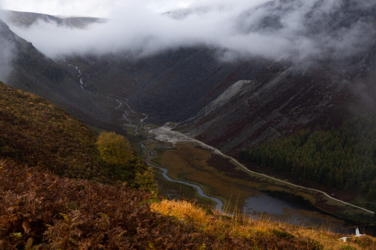
From Poulanass Waterfall you continue your walk upwards until you reach the junction on the picture down below. Here the blue arrow points towards the left as well as to the right since this is the point where the loop part of the hike starts. We decided to go to the right and made our way past the gate and up the hill. The next stretch was the most strenuous. You will be walking uphill until you reach the Spinc viewpoint. From here you get really great views over the Lower Lake as well.

The most scenic part of the hike starts when you reach the boardwalk. The boardwalk leads you through a beautiful grassland. The clouds were really low that day, but also moved really fast. One moment we were in the clouds and the next we had the most amazing views into the valley and on to the Upper Lake.

Wildlife
Up in the hills of the Wicklow Mountains National Park there are quite a lot of deer roaming around. Our most amazing encounter was however a small stag. It crossed our path 20 meters in front of us and then ran off into the woods. We were quite overwhelmed by it so unfortunately we did not get a good picture.
Just take this as a heads-up to keep your eyes open when walking these paths and maybe you will have such an encounter as well!
At the next junction, the Blue Route leads you to the left through the woods. You will be walking down a staircase which brings you to a broad path at the bottom of another valley.


Just follow this path back to the junction where you started the loop of the Blue Route before. This path follows a creek which runs at the bottom of the valley. There are sheep roaming around freely and we even saw some deer up in the hills.


Nearly at the end of the hike, you can take a small detour towards the Reefert Church. This small church was probably built in the 11th century and stands on an old burial place of the local rulers, the O’Toole family.

Hiking the Green Route to the Monastic City
The Green Route is a 3 km loop hike, which is considered to be easy. As compared to the Blue Route, the Green Route is actually more of a walk rather then a hike. There is no elevation. The main reason why we did the Green Route after finishing the Blue Route was that we wanted to see the Monastic City. The Green Route takes you around the Lower Lake.
The Monastic City is one of the most important monastic sites in Ireland. It dates back to the 6th century. If you wish to read more background information on this site, the tourism website of the County Wicklow provides a great overview.


After visiting the Monastic City, we made our way back towards the Upper Car Park. The Green Route leads you over some sort of footbridge towards the other side of the Lower Lake and then back to the car park. The views on this part of the walk were quite amazing as well.
